Arizona’s trails have a compelling tale to tell: First came the indigenous hunters and gatherers who found footholds in the canyon walls. Then came the explorers who forged pathways between the early missions and forts. And later came the railroad workers who blasted routes through rocky terrain.
There is no question that history runs deep in the scenic trails that take hikers and cyclists into the backcountry of the Grand Canyon State.
I have hiked many of Arizona’s famous historic trails over the years, and I am always delighted when I find a trail that blends beauty and backstory. Here are seven historic Arizona trails that you shouldn’t miss.
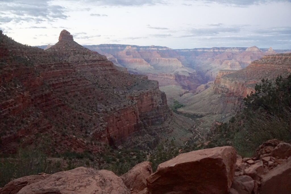
Centuries before tourists thronged the South Rim of the Grand Canyon for its stellar views and varied recreation options, the vast chasm was home to indigenous people.
The Grand Canyon National Park website notes that people have lived in and around the Grand Canyon for 12,000 years. In early days, the Havasupai and other native tribes are said to have followed animal paths into the canyon on hunting and food-gathering excursions.
Over the years, the foot traffic wore down a 4.5-mile path between the South Rim and the perennial waters at Indian Garden along a route the native people called Gthatv He’e (“Coyote Tail”).
Many of the native names for the canyon’s peaks and creeks were lost over time, and records trace the name Bright Angel Trail back to John Wesley Powell’s 1869 geographic expedition into the Grand Canyon. The Grand Canyon website says, “A hymn lyric came to [Powell’s] mind: ‘Shall we gather at the river, where bright angel feet have trod.’”
Today, the Bright Angel Trail is one of the premier recreational routes into the Grand Canyon. It is known for its sweeping views of the canyon walls and the Colorado River, as well as its connection to the lovely shady area at Indian Garden. The trailhead is located just west of the Bright Angel Lodge on the South Rim. The trail is described in this PDF.
Pro Tip: The 9-mile round-trip hike to Indian Garden and back to the South Rim involves an elevation drop and gain of more than 3,000 feet. It is rated as strenuous and should not be attempted in the midday summer heat. More tips for hiking below the rim of the Grand Canyon are available in my story 10 Tips For Hiking The Grand Canyon.
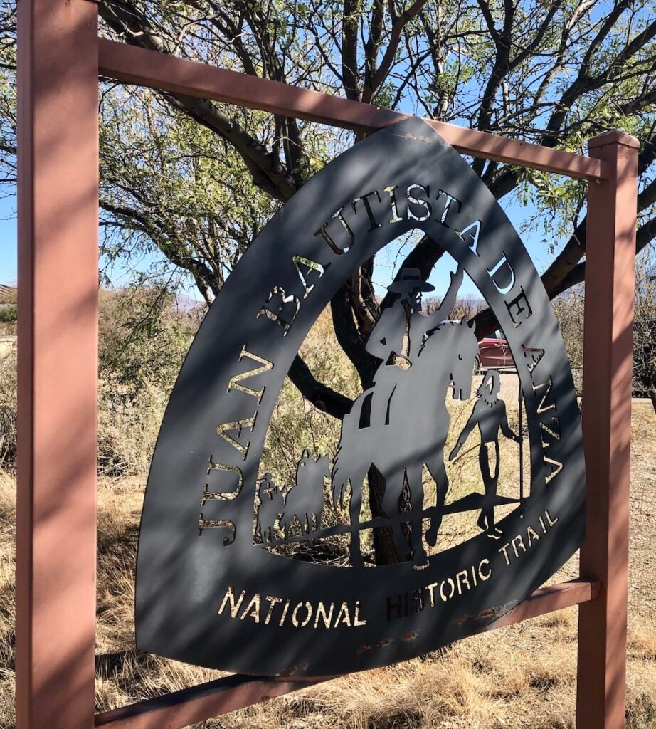
It is almost impossible to imagine today, but in 1775, an expedition made up of 240 men, women, and children mounted up to make the 1,200-mile trek from Nogales, Arizona, to San Francisco.
The journey was led by Juan Bautista de Anza, a Spanish military leader whose rallying cry was Vayan Subiendo! (“Everyone mount up!”) The purpose of the trip: to establish the first nonnative settlement at San Francisco Bay.
Today, the Juan Bautista de Anza National Historic Trail offers history, culture, and outdoor recreation along the route. In Arizona, the trail passes through the rugged terrain of the Sonoran Desert, connecting the historic mission of Tumacacori National Historical Park with the nearby Tubac Presidio State Historic Park. The trail can be accessed at the Tumacacori Mission ruins.
Pro Tip: The Juan Bautista de Anza Trail runs through a number of communities in southern Arizona, including Nogales. For ideas on things to do in the region, see my article The Best Things To Do In Historic Nogales, Arizona.

One of a few Rails-to-Trails projects in Arizona, the Peavine National Recreation Trail follows the route of the railroad that was originally built by the Santa Fe Railway in 1893.
The route was abandoned decades later, and today, a 6-mile stretch of the former railroad route is preserved as an exceptionally scenic recreational trail that passes by the shores of Watson Lake, one of several gorgeous lakes to explore in Arizona, and through the Granite Dells, an expanse of pink-hued granite rock formations.
A signature feature of the route is the Point of Rocks, a spectacular finger-like rock formation at about the halfway point. Directions to the trailhead are available here.
Pro Tip: The Peavine Trail is among the best outdoor activities on offer in the midsize city of Prescott. For other ideas, see 7 Fantastic Things To Do In Prescott, Arizona.
Following a route that was once used by prehistoric Native American travelers and traders, the Black Canyon Trail runs north-south for 80 miles through the wide-open spaces of the Sonoran Desert.
Along with its fascinating history as a travel corridor — first for Native Americans, then for stagecoaches, and later for livestock — the Black Canyon Trail showcases a range of desert cactus species, including saguaros, ocotillos, and chollas. It also offers wonderful views of the Agua Fria River.
The Black Canyon Trail can be accessed at a number of locations, and maps and directions are available here.
Pro Tip: After a wet winter, the Black Canyon Trail is a great place to spot spring wildflowers and blooming cacti. For more wildflower hikes, check out 5 Perfect Wildflower Hikes In Arizona.
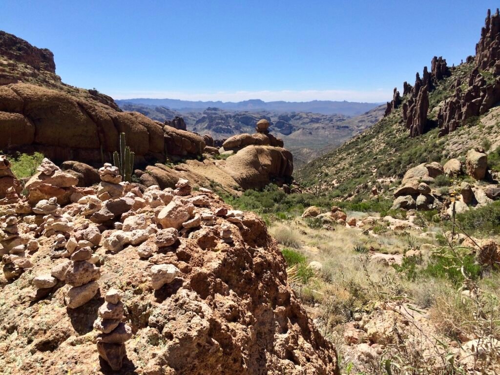
Along with its stunningly gorgeous surroundings, the Peralta Trail in the Superstition Mountains is steeped in Arizona mining folklore.
Named after 1700s cattle baron and landowner Don Miguel de Peralta, the trail passes by Weavers Needle, the most distinctive landmark in the Superstitions and a central part of the Lost Dutchman Mine legend.
Peralta’s land is said to have been the site of a rich gold mine not far from Weavers Needle. The location of the mine was ultimately lost, and it would later become known as the Lost Dutchman Mine after Jacob Waltz, who died before proving his claim. Lost Dutchman State Park commemorates the mystery of the mine.
Today, the Peralta Trail is among the most popular hikes in the Superstitions for its up-close views of Weavers Needle, as well as for its iconic desert terrain. Directions to the trailhead are available here.
Pro Tip: The Peralta Trail is not far from the Phoenix-area community of Apache Junction. For other things to do there, see The Best Things To Do In Apache Junction, AZ During Winter.
It would be difficult to find a closer encounter with the ancient cultures of Arizona than the Island Trail at Walnut Canyon National Monument. The mile-long trail passes by 25 cliff dwellings left behind by the Sinagua, who flourished in the area from about 600 to 1400.
“Along the trails you can imagine life within Walnut Canyon, while visiting actual pueblos and walking in the steps of those who came before,” says the national monument’s website.
Pro Tip: Walnut Canyon is located in the steep terrain about 12 miles east of Flagstaff. The mountain town makes a perfect base for exploring the national monument. For other things to do in the area, see 9 Ways To Spend A Beautiful Fall Weekend In Flagstaff.
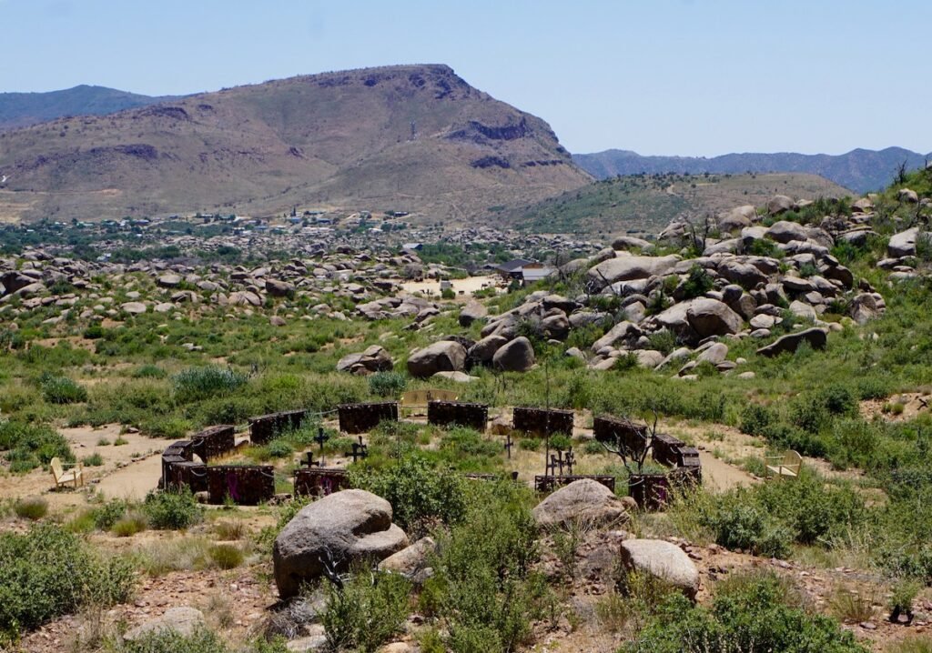
A somber step back into a more recent era of Arizona history is available at the Hotshots Trail, a 7-mile round-trip hike that follows the route that a crew of elite Hotshot firefighters took to fight a wildfire that raged near the town of Yarnell on June 30, 2013.
Nineteen of the young men died that day fighting the Yarnell Hill Fire. Two years later, the state dedicated the Granite Mountain Hotshots Memorial State Park. The Hotshots Trail features interpretive signs, as well as 19 plaques telling each man’s story. It also offers sweeping views of the surrounding valley and classic high-desert terrain.
Featuring a 1,200-foot elevation gain, little shade, and no water sources along the route, the hike is strenuous, and it should not be attempted during the hot-weather months. But if you’re able, the hike is a memorable endeavor and a time-honored way to pay your respects to the fallen Hotshots.
Pro Tips: Parking is limited at the state park, and a shuttle is available to the trailhead from Yarnell. The Hotshots Trail makes a worthwhile detour on a drive from Phoenix to the Colorado River Corridor. For other ideas, see Phoenix To Lake Havasu City: A Road Trip To Arizona’s West Coast.